--------------------------------------------------------------------------------
Geographic Names Information System Query Results
BONNERTOWN, TENNESSEE
HOME | CATEGORIES | TOC | SURNAME LIST | BONNER PEOPLE | BONNER PAGES
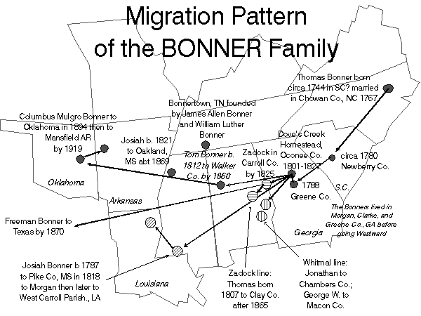
Bonner Migration
--------------------------------------------------------------------------------
Geographic Names Information System Query Results
BONNERTOWN, TENNESSEE
--------------------------------------------------------------------------------
5 Feature records have been selected from GNIS.*
--------------------------------------------------------------------------------
Feature Name: Bonnertown
Feature Type: populated place
Elevation: 852
State: Tennessee
County: Lawrence
USGS 7.5' x 7.5' Map: Bonnertown
Latitude: 350022N
Longitude: 0871753W
Show Feature Location
Show Feature Details
Feature Name: Bonnertown Baptist Church
Feature Type: church
State: Tennessee
County: Lawrence
USGS 7.5' x 7.5' Map: Bonnertown
Latitude: 350025N
Longitude: 0871754W
Show Feature Location
Show Feature Details
Feature Name: Bonnertown Cemetery
Feature Type: cemetery
State: Tennessee
County: Lawrence
USGS 7.5' x 7.5' Map: Bonnertown
Latitude: 350018N
Longitude: 0871805W
Show Feature Location
Show Feature Details
Feature Name: Bonnertown Methodist Church
Feature Type: church
State: Tennessee
County: Lawrence
USGS 7.5' x 7.5' Map: Bonnertown
Latitude: 350022N
Longitude: 0871757W
Show Feature Location
Show Feature Details
Feature Name: Bonnertown School (historical)
Feature Type: school
State: Tennessee
County: Lawrence
USGS 7.5' x 7.5' Map: Bonnertown
Latitude: 350028N
Longitude: 0871750W
Show Feature Location
Show Feature Details
*In some cases, you may see a difference between this record count
and the actual number of detail records shown below. This is due to a limitation
in the design of the web query, and reflects records with an unknown map
name. It was originally designed this way to increase performance on the
web. We are working on a resolution to this problem. In the meantime, you
r patience and understanding are appreciated. If you have questions, please
contact the maintainer as shown below.
--------------------------------------------------------------------------------
| GNIS Query Form | Mapping Information |
--------------------------------------------------------------------------------
URL: http://mapping.usgs.gov/www/gnis/gnisayub
Maintainer: gnis_manager@usgs.gov
Last modified: 15:09:38 Wed 24 Sep 1997 dlg
Site copyright 1999, 2000, 2001 Trish S. Carden (Please feel free to use this information but if you do please put a link back to this page)