Revolutionary War Era
Moore's Creek Bridge, NC Feb 27, 1776
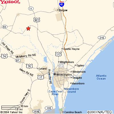
The Widow Moore's Creek mentioned is just across the Cape Fear
River from Wilmington, North Carolina. See Red Star on Map
Moore's Creek Bridge, NC Feb 27, 1776
The Widow Moore's Creek mentioned is just across the Cape Fear
River from Wilmington, North Carolina. See Red Star on Map
The Battle
The Tory council of war decided to attack at dawn on February 27,
1776. Lt. Colonel Donald McLeod took active command. At 1:00 A.M., they
set out. Although they numbered 1,600, they had only 500 firearms. When
they reached the bridge, they found empty entrenchments. The Rebels had
withdrawn to the other side of the bridge.
An advance party found half of the bridge planks had been removed and the two stringers had been greased. But Lt. Colonel McLeod would not be denied. An eighty man assault force armed with broadswords was assembled under the command of Captain John Campbell. The assault force followed McLeod down one stringer and Campbell down the other to the beat of drums and the Scottish war pipes.
The Rebels held their fire until Campbell and McLeod crossed the creek and then they let loose with their two cannon and musket fire. No one was left standing on the bridge. Campbell and McLeod were killed immediately. Some Tories fell into the creek and drown. Their companions who had watched their quick defeat immediately retreated.
Aftermath
Thirty Tories were counted dead, while the Rebels had only two casualties,
one of whom later died of his wounds. 850 Tories were captured, including
Brig. General MacDonald. This quick defeat ended organized Tory activity
in the area for several years. Less than two months later in April, North
Carolina became to first state to vote for independence.
To all Highlanders who pledged service to the Crown the British government promised 200 acres of land, cancellation of land fees, and tax exemption for 20 years. These terms, and Martin's efforts among other groups, brought in recruits, though not nearly as many as had been expected. The call went out for loyalists to assemble under MacDonald near Cross Creek (Fayetteville) and then march to the coast. When the force was organized on February 15, there were about 1,600 men present: Highlanders, other loyalists, and some 130 ex-Regulators.
The loyalists' plan was to advance along the southwest side of the Cape Fear to the coast, provision the British troops arriving by sea, and then join them in conquering the colony. On February 20, 1776 MacDonald began his movement toward the coast. Blocked by Moore at Rockfish Creek, he marched eastward in the general direction of Caswell's force, crossed the Cape Fear, and proceeded toward the Negro Head Point Road, a route into Wilmington along which he expected little opposition. Outmaneuvered by MacDonald's march tactics, Caswell withdrew from defending Corbett's Ferry on the Black River in order to "take possession of the Bridge upon Widow Moore's Creek." some 20 miles above Wilmington and a place the loyalists had to cross on their way to the coast. After sending Col. Alexander Lillington to join Caswell, Moore fell back toward Wilmington, hoping to fall on the rear of MacDonald's column as Caswell obstructed him in front.
Meanwhile, the patriots had not been idle. While Martin tossed at sea, they began to mobilize their forces. Since Martin was technically out of the colony, the patriots in August and September 1775 set up a Provincial Council to govern in his place. Upon the recommendation of the Continental Congress, two regiments of the Continental Line and several battalions of minutemen and militia were raised.
At the news that the loyalists were assembling at Cross Creek , the patriots began gathering their forces. In Wilmington they threw up breastworks and prepared for fighting. In New Bern authorities mustered the district's militia under Col. Richard Caswell and ordered it to join with other militia in countering the loyalists. Col. James Moore, the senior officer of the 1st N.C. Continentals and the first to take the field, was given command.
The loyalists' plan was to advance along the southwest side of the Cape Fear to the coast, provision the British troops arriving by sea, and then join them in conquering the colony. On February 20, 1776 MacDonald began his movement toward the coast. Blocked by Moore at Rockfish Creek, he marched eastward in the general direction of Caswell's force, crossed the Cape Fear, and proceeded toward the Negro Head Point Road, a route into Wilmington along which he expected little opposition. Outmaneuvered by MacDonald's march tactics, Caswell withdrew from defending Corbett's Ferry on the Black River in order to "take possession of the Bridge upon Widow Moore's Creek" some 20 miles above Wilmington and a place the loyalists had to cross on their way to the coast. After sending Col. Alexander Lillington to join Caswell, Moore fell back toward Wilmington, hoping to fall on the rear of MacDonald's column as Caswell obstructed him in front.
The Engagement at the Bridge
When Lillington arrived at the bridge on the 25th, he quickly
saw the position's defensive advantages. The creek, a dark, sluggish, stream
about 35 feet wide, wound through swampy terrain and could be crossed in
the vicinity of only over this bridge. To dominate the crossing, Lillington
built a low earthwork on a slight rise overlooking the bridge and its approach
from the east. Joining Lillington the next day, Caswell sent
his men across the bridge to throw up earthworks there. Thus by the evening
on February 26, the patriots straddled the bridge. Lillington with 150
men waited on the east side of the creek, and Caswell with 850 men
were camped on the west. MacDonald's loyalists, 1,600 strong but with arms
for less than half that many, camped 6 miles away.
MacDonald had lost the race to the bridge and now had to decide whether
to avoid fighting once more or to cut through their opponents. At a council
of war the younger leader carried the debate, and eventually all agreed
that the enemy should be attacked. An element in the decision was the report
by a scout that Caswell's position lay on their side of the river and was
thus vulnerable.
At 1 a.m. on the 27th the loyalists set out on their march to the attack, with a party of 75 picked broadswordsmen under Capt. John Campbell in the lead. By now MacDonald had fallen ill, and Donald McLeod was in command. The going was slow, for the route lay through thickets and swampy ground. During the night Caswell abandoned the camp and withdrew across the creek. Once on the other side, Caswell's men removed the planks and greased the girders. Posting artillery to cover the bridge, they waited in darkness for the advancing Scots.
An hour before dawn the loyalists came upon Caswell's deserted camp and found the fires burning low. Moving on to nearly woods, McLeod regrouped his men and passed the rallying cry - "King George and Broad Swords" - along the line. There they waited for daybreak. Suddenly gunfire sounded near the bridge. Though it was not yet light, McLeod couldn't wait any longer. Three cheers rang out - the signal for the attack - and the loyalists rushed the partly demolished bridge with broadswords out and bagpipes skirling. Picking their way over the bridge and onto the opposite bank, they got within 30 paces of the patriot earthworks before they were met by a withering fire of musketry and artillery. Nearly all the advance party were cut down, and the whole force soon retreated. It was all over in a few minutes. Pursuit turned the repulse into a rout. The loyalists lost some 30 killed and 40 wounded. Only one patriot died.
Within weeks the patriots had captured "all suspected person" and disarmed "all Highlanders and ex-Regulators that were ... in the late battle." The spoils included 1,500 rifles, 350 "guns and shot-bags," 150 swords and dirks, and £15,000 sterling. Some 850 "common Soldiers" and most of the loyalists were captured. The leaders were imprisoned or banished from the colony. The soldiers were paroled to their homes.
Though the battle was a small one, the implications were large. The
victory demonstrated the surprising patriot strength in the countryside,
discouraged the growth of loyalist sentiment in the Carolinas, and spurred
revolutionary feeling throughout the colonies. The British seaborne force
, which finally arrived in May, moved on to Sullivan's Island off Charleston,
S.C. In late June patriot militia repulsed Sir Peter Parker's land and
naval attack, ending the British hopes of squashing rebellion in the South
for two years. "Had the South been conquered in the first half of 1776,"
the historian Edward Channing concluded, "it is entirely conceivable that
rebellion would never have turned into revolution ... At Moore's Creek
and Sullivan's Island the Carolinas turned aside the one combination of
circumstances that might have made British conquest possible."
Traces of the Past
This 86-acre park preserves the site of the Revolutionary War Battle
of Moore's Creek Bridge, fought February 27, 1776, between loyalists and
patriots of North Carolina. The only original remains are the bridge site
and a stretch of the old Negro Head Point Road. In 1856 a Wilmington newspaper
reported that some of the original bridge's foundation timbers could still
be seen, along with traces of the earthworks. The earthworks we see today
were reconstructed in the late 1930s. They are based on an assumption that
Col. Alexander Lillington, commanding the first patriots to arrive at the
bridge, threw up an encirclement of breastworks - in effect an armed camp
- to ward off raiding parties that might ford the creek and attack him
side or rear. In this position, Lillington straddled the road over which
the loyalists would have to come if they had managed to cross the bridge.
One flank was anchored by swampy ground, the other by the meandering creek.
Excavations in 1974 failed to turn up any evidence that the reconstructed
earthworks are similar to or even located in the same place as the original
earthworks. What is therefore on view today is a plausible attempt by an
earlier generation to lend conviction to the historical scene.